


Squinting at his computer screen in his office in Kinshasa, Dr. Albert Kadjunga scrolls through a map of Kasai province in central Democratic Republic of Congo (DRC), pointing to a beige area sandwiched between streaks of blue.
“You can see here, the parts colored blue show communities that live less than a 60-minute walk from an existing health center or community care site,” he explains. “This [beige area] is where one of the new community care sites will be set up.”
For Kadjunda, the technical director at the National Programme for the Elimination of Cholera and the Control of Other Diarrheal Diseases (PNECHOL-MD), installing community care sites (CCSs) in remote communities is a crucial weapon in the fight against deadly childhood diseases.
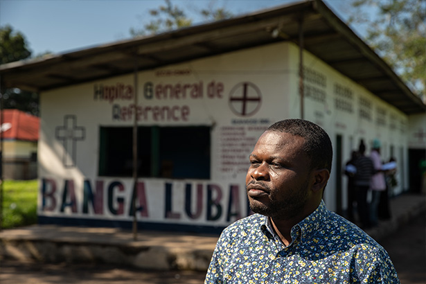
Dr. Albert Kadjunga poses for a photograph outside the general hospital in Banga Lubaka, a town in rural Kasai Province, DRC.
A community care site provides an initial level of healthcare for people living in remote areas, run by trained volunteers it can provide basic yet lifesaving testing and treatment of cholera, malaria, and pneumonia.
Until recently, their locations were based on outdated and limited population data, meaning that community care sites weren’t implemented where they were most needed. With CHAI’s support, Kadjunga’s team is now trialing the use of a range of geospatial data that optimizes locations, improving access for the most vulnerable.
“A big cause of death is when children arrive late at a health center in distress, it’s difficult to care for them when the illness has been left untreated,” says Kadjunga.
In a country where less than 2 percent of roads are paved, over 70 percent of the population live on less than US$2 per day and only 30 percent live within easy access of a health center, it’s perhaps not surprising that over 80 percent of deaths occur at home or on the way to find treatment. DRC also has one of the highest rates of child mortality in the world, with every passing hour 185 children under five die.
To reduce child mortality’s heavy toll, the government aims to establish community care sites in all communities which are further than five kilometers from a health service. The sites are run by trained volunteers who can diagnose and treat simple cases of potentially deadly diseases, spot dangerous symptoms and refer patients to health centers for more serious cases when needed.
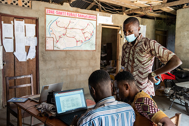
Colleagues work at the BCZ in front of a map of the Banga Lubaka Health Zone with locations for new community health care sites.
In DRC, where the last population census was in 1984, finding the most effective sites for CCSs is a complicated task. Previously, Kadjunda and his colleagues were handed tables of population estimates collected by under-resourced staff at the local level and used these to decide where CCSs should be installed. The data was patchy, says Kadjunda, and lacked any kind of precise or up-to-date information on population or geographic features.
In 2021, the Clinton Health Access Initiative (CHAI) and the Geo-Referenced Infrastructure and Demographic Data for Development (GRID3) helped introduce Kadjunga and his team at the ministry of health to the world of geospatial data. Combining satellite data, micro population surveys, and modeling, GRID3 produced open-source maps which incorporate a range of metrics such as population and density, infrastructure, and geographic features that are helpful for understanding access to healthcare services.
“We hadn’t heard of or seen this kind of geospatial data before,” said Kadjunga. “It gives precise information on the location of the sites, population, and distance from a health center.”
Under the Exemplar Use of GRID3 for Primary Health Care project, CHAI is providing technical support to Kadjunga’s team to trial the use of GRID3’s geospatial data to select the location of ten community care sites across two health zones in Kasai province – the region with the highest rate of child mortality in the country.
“With these maps, we now know the walking time from settled areas to the nearest health center and existing community care site,” explains Kadjunda as he points to the blue areas on the map. “We also know which populations are cut off from a health center by a natural barrier–for example, a forest, a river, or a conflict, and what is the exact population density that will be covered by the site.”
To date, it is estimated that only 12 percent of communities across the country have community care sites. With over 60,000 more to set up, Kadjunda hopes the use of geospatial data will bring healthcare closer to those who need it.
“We definitely want to use [geospatial] data going forward, we’ll be incorporating this into our methodology and process,” says Kadjunda. “It will help us in the fight against child mortality.”
“CHAI has demonstrated the importance of geospatial data to identify populations which are not well served by health services,” said Symphonie Muandamundele, CHAI’s deputy country director. “Our strategy is to use this approach across the whole province of Kasai, and why not, across the whole of the Democratic Republic of Congo.”
Contributing authors:
Jeanne Umuhire, Associate Director, Infectious Diseases and Neglected Tropical Diseases, and Jean-Robert Numbi, Analyst, Malaria, Democratic Republic of Congo
